I met “Chuck” Parsons and his wife whilst conducting a group at Arthur Barbera’s 300th Anniversary of the battle of Malplaquet weekend in 2009.
Chuck has approached the battle of Blenheim from a different perspective and I think you will agree that, although only speculation on his part, it is well worth further investigation.
Graham Morris
10 March 2020


Part 1: Introduction.
1.1 Classic accounts of the Battle of Blenheim follow the description given in Sir Winston Churchill’s account contained in his work titled ‘Marlborough, His Life and Time’. In the main they rely on correspondence and eye-witness accounts as their source material. There are good grounds to believe that correspondence in the early 18th Century was liable to interception. Marlborough is quoted by Sir Winston with spreading disinformation, and must have been aware of the opportunity intercepted correspondence could give in this area. In consequence, any reports of plans or actions which originate from letters written in the field by Marlborough must be treated with suspicion, unless there is independent confirmation.
1.2 Both Marlborough and Eugene had no false idea about the problem of defeating the French army, nor of how long this might take. In consequence they must have been circumspect in their contemporary account of what tactic was used to obtain victory in a particular battle.
1.3 The highly infectious disease affecting Tallard’s cavalry horses had such a decisive bearing on the outcome, that the question must be posed if this might have been deliberately introduced. In the 18th century, horses were a vital component in an army’s mobility, it can easily be forgotten how many were required by both sides. Providing for their health and hunger was a major problem for an army’s logistics, and foraging was not just a euphemism for looting.
1.4 Marlborough’s campaign in south Germany raises many questions that deserve an answer if the full story is to emerge. Some of these answers can only be conjecture, but qualified conjecture is better than false facts based on prejudice or disinformation. Marlborough appears to have had more than his fair share of detractors, some of whose complaints might have had something more substantial than envy and jealousy to substantiate them. Irrespective what the truth is, England and Europe were very fortunate to have had him as army commander in the War of Spanish Succession.
Part 2: Observations dealing with the physical properties of the battlefield
2.1 The battlefield is located along the lower 6 kilometres of the Nebelbach valley on the north bank of the Danube. Between Dillingen and Donauworth, a road distance of about 28km, the Danube was a serpentine river between 50 and 100 metres wide, up to 2 metres deep, flowing in a mean north-east direction at up to 10km per hour.
2.2 The Nebelbach stream flows in a south east direction, to empty into the Danube at the village of Blindheim. Blindheim church is about four kilometres north-east of the main church in the riverside market town of Höchstädt, which is about 8 km from the castle at Dillingen.
2.2.1 Lutzingen. The area occupied by the Franco-Bavarian forces under command of the Elector, Max Emanuel 2nd of Bavaria.
2.2.2 Höchhstädt. Gives its name in Germany to the battlefield, and is the central area containing the village of Oberglauheim (Oberglau of the Classic accounts), which was occupied by the Franco-Bavarian forces under command of Marshal Marsin.
2.2.3 Blindheim (The Blenheim of the Classic accounts). The area containing the villages of Unterglauheim (Unterglau of the Classic accounts) and Blindheim which was occupied by a French army under command of Marshal Tallard.
2.3 The area of the battlefield and its eastern approaches was enclosed by the heavily forested Jura hills to the north and the Danube to the south. A forested spur partially enclosed the western end of the battlefield, but there was a three kilometre gap between this spur and Höchstädt.
2.3.1 The hills to the north closed in towards the Danube, and gave a triangular shape to the area, which was reduced from six kilometres wide at the western end to slightly over a kilometre wide at Tapfheim.
2.3.2 The eastern end had deep reverse slopes between Schwenningen and Tapfheim, which covered the approach from the east to observation, until about three kilometres to the east of Blindheim.
2.4 The Nebelbach stream was the main drainage of the area, and was fed near Oberglauheim by several subsidiary streams. One of these, the Kugelbach, flowed from the hills to the north through Schwennenbach. Two originated in the woods on the spur to the west, and flowed through a very damp, soft basin containing water meadows, before joining the Nebelbach.
2.5 An additional subsidiary stream, the Weiherbrunnenbach, flowed in its own shallow valley from Lutzingen through Blindheim into the Nebelbach near its mouth. The part of the Nebelbach west from Oberglauheim shown in Ref 1, is the Oberer Ried Graben and was the start line for Eugene’s attack. The correct course of the Nebelbach is shown in Ref 4. What were once healthy streams are now little more than ditches.
2.6 The subsoil is a product of fallout from the Ries event. The southern rim of this twenty-five kilometre meteor crater lies twelve kilometres to the north. Most of this fallout was removed from the hills by the Ice Ages. The exposed limestone was quarried in the middle ages, and reduced to lime in kilns and mills along the various streams in the area, which gives a good idea of the water flow available in the 18th century.
2.7 Modern flood control measures and water extraction have altered the water table along the Danube valley, and this has affected not only the flow of water from its many small tributaries, but has also been the cause of asymmetric land subsidence in all of these valleys. For example, the Lechfeld between Augsburg and Mühlhausen has sunk two metres in the last hundred years.
2.8 In 1704, permanent cart tracks criss-crossed the forest to the west and north to allow access and the removal of timber as well as the limestone. A combination of these provides the shortest path between Eugene’s camp at Oppertshofen, four kilometres to the north of Tapfheim in the Kessel valley, and his infantry start line just to the south of the Eichbergerhof about two kilometres north of Lutzingen.
2.9.1 The high ground of the Riedberg between Lutzingen and Oberglauheim, is part of a bank which in 1704, extended from Lutzingen past Oberglauheim to Unterglauheim. The practice of the local farmers to plough their fields with the slope, combined with the very heavy thunderstorms which are a feature of this area, have washed out the bank east of Oberglauheim, leaving only a short three hundred metre stretch opposite Unterglauheim. This bank is shown shaded in Ref. 3.
2.9.2 There is a gentle (1:250) one kilometre rise from this bank to the crest to the south, along which runs the railway line and adjacent main road, which follow the line of the original Roman road. The bank referred to in para. 2.9.1, is about 50 metres from the Nebelbch, and was steep and high enough ( at least 3 metres) to provide dead ground for troops forming up after having crossed the Nebelbach, to observation by troops located on this slope. It is not shown on modern 1:20000 topographic maps.
2.10 Climbing a few steps of the new observation tower on contour 425 at map ref (UTM zone) 32 6179 East, 53 885 North, allows experience of the horse back view available
to Tallard and shows how bad his observation of the battle field was and thus the control he could exert.
2.11 The Duke of Marlborough on the other hand, located as he was near Berghausen on spot height 468 at map ref 6177 East, 53915 North with his 43 metre height advantage, had an excellent horseback overview of the whole battlefield, and thus could maintain a tight control of how the battle developed.
2.12 The Nebelbach, which is the lowest point on the battlefield between these points is at contour 415. (The Nebelbach at the modern main-road bridge in Blindheim is also in dead ground to observation from the X roads by the church in Blindheim).
2.13 Slight folds in the ground were sufficient to limit the view through the smoke of battle and burning villages, which was available to the infantry. The prevailing wind which normally is channelled by the land profile in this area to blow from the north-west along the Nebelbach valley, would have worsened these conditions to the south-east. Mass musket fire was mainly at the extremities and in the middle of the battlefield.
2.14 Although prominent landmarks, none of the church towers would have been practical observation posts for control of the battle.
2.15.1 Although prominent landmarks, none of the church towers would have been practical observation posts for control of the battle.
2.15.2 A partial explanation, is the fact that between the battle over the same area fought by Count Styrum in September 1703, and the battle in August 1704, the farmers had fled the area, and no land maintenance was carried out. This meant the detritus of the 1703 battle still choked the streams. After the clearing of the battlefield in 1704, the land workers returned to the area and normal land husbandry was once again carried out.
Part 3: Observations on the location of the battlefield
3.1 There is one question about the battlefield which must be addressed, as it is basic to the South German campaign. This is:-
3.1.1 Was it a coincidence that the battle was fought on the only area in the one hundred kilometre stretch along the Danube north bank between Ulm and Ingolstadt, which gave an overwhelming tactical advantage to the forces approaching from the east.
3.2 These are:-
3.2.1 A terrain limited site which allows a decisive battle to be fought which will result in the destruction of the army occupying the south bank of the Nebelbach.
3.2.2 A site which allows near perfect observation and control from an elevated central position, to the Commander of the army occupying the north bank.
3.2.3 Emergency exits for the army occupying the north bank, not only the steep paths to the north defended by Styrum in 1703, but also through a narrowing area to the East under the cover of reverse slopes. All of these emergency exits had excellent connections with the main magazine situated twenty five kilometres to the north at Nordlingen.
3.2 A land profile whose gentle slopes tempted the army on the south bank to retire behind the apparent protection of the flooded Nebelbach, and defend the villages along the south bank.
3.4 A tactically better defensive position for Tallard would have been across the narrow area near Tapfheim.
3.5 Bearing in mind the competence of the two Commanders, Marlborough and Eugene, it is difficult to believe that chance entered into the selection of the battle site, so the question that needs to be answered is:-
3.6 When was this site selected?
3.7 All of these facts were well known to the majority of Eugene’s army, who were defeated there the previous year under the command of Count Styrum. So there must be a very strong possibility that at the Gross Heppach meeting of the three Commanders, Marlborough was made aware, not only of the experiences of Count Styrum at the Blindheim site, but also of the advantages this site held to fight a decisive battle, which would result in the destruction of the Franco Bavarian forces, and remove their threat to Vienna.
3.8 This means that at the meeting at Gross Heppach, a combined strategy was decided on that must have included the following:-
3.9 A battle at the Schellenberg, so that Marlborough and Baden could cross the Danube and insert their combined army between the Franco Bavarian army and its Magazine in Bavaria.
3.10 The destruction of Western Bavaria to prevent essential re-supply of feedstuffs to the Franco Bavarians from their west Bavarian magazine.
3.11 An apparent isolation of Eugene’s army to tempt the Franco Bavarian army to cross the Danube to the killing ground of the Nebelbach.
3.12 Isolation of the strong garrison at Ingolstadt by staging a siege, so as to prevent Marlborough and Eugene being the filling in an embarrassing sandwich, as happened to Count Styrum the previous year.
3.13 It is probable that the allocation of the various tasks was determined more by the composition and location of the various forces at the time of the Gross Heppach meeting, and not by any personality clash between Eugene and Baden.
3.14 This policy to destroy the Franco Bavarian forces provides a credible explanation as to why the battle of the Schellenberg was worth over 3000 casualties to capture a remote hilltop in south Germany. It not only explains why it was essential to keep this strategy a closely guarded secret, but also provides credible answers to the questions:-
3.15 (Question) What was Eugene’s army doing during the four days it was camped in the Höchstädt area?
3.15.1 (Answer) It was preparing the battlefield by not only ensuring the Nebelbach valley was isolated and flooded, but also that a supply of fascines were positioned adjacent to the proposed ‘March In’ route.
3.16 (Question) Why was the defence of the Schloss in Höchstädt so important?
3.16.1 ( Answer) It ensured that the Franco Bavarian army would overnight in the Nebelbach valley, behind the tempting defensive moat of the flooded Nebelbach.
Part 4. Observations on the classic ‘English Based’ description of the Battle of Blenheim.
4.1 The classic description of the battle of Blenhiem follows the account to be found in Ref. 9.
4.2 The well known German ‘Action Historian’ Dr. Marcus Junklemann’s contribution to the ‘Jahrbuch for 2004’ of the Dillingen Historical Society (Ref. 19) raises serious doubts about the accuracy of these accounts, and needs careful examination.
4.3 Further to these, the following questions also need an answer:-
4.3.1 Did Eugene make any use of the shorter forest cart tracks which existed between his overnight camp in the Kessel valley, and his infantry ‘Start Line’ to the north of Lutzingen?
4.3.2 Did Eugene make any attempt to block these forest cart tracks to the Franco Bavarian army?
4.3.3 Did Eugene destroy as a delaying tactic, the main east/west road bridge near Unterglauheim during the period he was retiring before the Franco Bavarian army, that the classic accounts state needed repair?
4.3.4 What significance is there in the fact that the only facts that all accounts are in agreement about are:-
-
-
-
- The overall development of the battle.
- That this defeat of the Franco Bavarian army resulted in the capture of a travelling brothel consisting of 34 coaches of French prostitutes.
- That the ‘March In’ consisted of nine separate columns and identified their individual composition – although it was night when the ‘March In’ started, and the greater part of their combined journey was made in conditions of heavy mist, both of which would make confirmation of the columns and their composition difficult.
-
-
4.2 The following questions also require answering,
-
- How exactly was Eugene’s artillery and its supplies got to the artillery ‘Start Line’?
- What arrangements existed for re-supply during the engagement? For example, Marlborough’s 50 cannons could well have fired over 1000 Rounds per Hour, over a front of 6 kilometres.
- Is there any truth in the folklore that the ‘Goat Herder’ Gaiss Hans, was rewarded by Eugene for guiding his army through the forest with a substantial sum, which enabled him to rebuild his farm in Schwennenbach? This is well documented in Ref. 11 to 14, and partially confirmed in Ref. 7.2. In which case, where was the wood path he used, as the only existing east/west wood paths are those referred to in para. 4.3.1
- When how and why did Eugene meet Gaiss Hans (Johann Steinle, now Beck)?
- Was Eugene’s initial success, which resulted in his infantry over-running the Bavarian artillery, because Gaiss Hans led an assault party through the woods so as to by-pass the artillery position, and allow them to attack it from the rear?
- Is this the act for which Eugene rewarded Gaiss Hans, which gave him enough money to finance the rebuilding of his home in Schwenenbach?
- Was the act of burning various villages done to destroy evidence of criminal acts, as it served no military purpose, and must have taken time to accomplish?
- What is the time-table for the various events from first light, through sunrise, to when the French started their artillery barrage at 0800hrs?
- When was the alarm first raised by the Franco-Bavarian army?
- What was the visibility from first light to this time?
Part 5. Observations dealing with the accuracy of the maps appearing in the flyers
(Ref 1 and 3), as compared with modern topographic maps available from the Bayerisches Landesvermessungsamt, (Ref. 4 and 5).
5.1 Accurate maps of this area first appeared as a result of surveys carried out on the instructions of Napoleon in the early 19th century.
5.2 In order to compare the accuracy of the early maps it is useful to compare how accurately known existing features are depicted. For example the orientation of the towns to each other, as well as the shape and orientation of the fortified area of Höchstädt and its castle are useful checkpoints (Ref.5).
5.3 Both Ref.1 and 3 have points which can be checked, and Ref. 3 depiction of the castle and walls of Höchstädt is superior to that of Ref. 1. (Höchstädt has an east/west axis)
5.4 A serious fault with Ref.3 is that the main road actually passes through the north-western part of the town, as shown in Ref. 6, and there is not room enough in the immediate surrounds, between the moat adjacent to Höchstädt’s north-western corner (Ref. 6), and the morass associated with the Pulverbach and Closterbach, to safely by-pass the town in order to get to the bridges over the streams. The bridge over the Pulverbach was located near to where the Rathause now stands, just to the north of Höchstädt’s north gate, and the stream flowed about 50 metres from the western moat.
5.5 This meant that the Franco Bavarian army had to pass along the existing main road, which entered the town through the town’s west gate and exited through the north gate, requiring the reduction of its garrison.
5.6 There is a very good likelihood that a general of Eugene’s capability would also have ensured the destruction of all the bridges over these streams during his stay in the area, so as to slow the rate of advance of the Franco Bavarian army, in order to give Marlborough time to unite their forces.
5.7 Both of the streams in para. 5.4 drain a marsh basin about ten kilometres north west of Höchstädt, and Eugene could well have partially blocked these streams with fascines in order to cause them to flood, and so close the gap between the Jura spur and Höchstädt available for the passage of wheeled traffic.
5.8 This would explain not only the very high loss of the Franco Bavarian wheeled transport and artillery, but also the capture of the travelling brothel, as the low ground adjacent to these streams would have been too soft for their weight.
5.9 One point that is not covered in any account of the battle is the length of the frontage of Eugene’s infantry’s first and second attack waves. It is not known with certainty if they were formed up in three or five ranks, but whichever formation was used, there were normally short gaps to allow access paths for their own cavalry between major formations.
5.10 With three ranks, and minimum gaps between formations, 9,000 troops would need about three kilometres of frontage. With two attack waves, this would be 1,5 kilometres per wave.
5.11 With five ranks this is reduced to 900 metres.
5.12 The gap between the woods on the western spur and Oberglauheim, also included a heavy cavalry engagement that was separate from the infantry action, and ref. 3 shows the border of the wood to be further east than the modern topographic maps. This gap could have been as little as one kilometre wide, and also had to accommodate a cavalry action involving seven thousand cavalry in two attack waves.
Part 6. Observations on other classic descriptions of the Battle of Blenheim.
6.1 Further to Dr Marcus Junkelmann’s criticism of Charles Spencer’s book (Ref. 8). There is a possibility the high ground above the village of Blindheim he refers to on page 286, from which he alleges the dragoons of Lord Hay’s regiment fired down, is either a gross exaggeration of a negligible rise (3 metres in a thousand) or exists only in his imagination.
6.2 The nearest high ground to Blindheim village is the small knoll at map ref 6 182 East, 53 883 North which contains the 1954 memorial of the battle of Blenheim. In 1704 this was about a kilometre from the nearest house.
6.3 Blindheim village in the early 19th century is depicted by a model in the Rathouse, and consisted of about 120 houses, mostly contained in a circle 500 metres in diameter based on the church, with a few houses lining the road to the Danube bridge to the South. The Schloss was demolished in the early 19th century, and was outside the village to the east, on Schloss Strasse (Ref. 16).
6.4 No mention is made of the very high standard of the Bavarian army, due to Max Emanuel’s founding of a military academy in Munich, which also carried out weapon and tactics development.
6.5 A little known fact is that the military academy had developed small hand held grenade launchers, artillery breach loaders, rifled barrels, as well as conical projectiles for masonry penetration (Ref 20). Staudinger is not clear as to whether these weapons were used by the Bavarian forces during the battle.
6.6 Between Blindheim and Höchstädt, the land drops steeply about 4 metres to the water meadows of the north bank of the Danube. Local excavation for gravel (Ref.15) has produced no relics upstream of the village of Sonderheim. This identifies where the catastrophe which drowned many of the French riders took place.
Part 7. Observations on the cost in Casualties and Government funds of the Battle of Blenheim.
7.1 There is no agreement about the casualty figures for the battle of Blenheim. The question of casualties is complicated because the Colonels of various regiments used phantom troops to obtain payments from the government to either line their own pockets, or to establish funds to provide rudimentary pensions for soldiers crippled in action. These phantom troops would later be declared ‘Killed in Action so as to keep the books square for accounting.
7.2 There are no known mass graves dating to 1704, and the civil authority clearing the battlefield of corpses, could well have used the Danube as a convenient cemetery. In any case there was also a battle fought on this site in the Napoleonic wars.
7.3 According to the records of the München Bayer. Hauptstaatarchiv for Pfalz-Neuburg (NA 1989 Nr 6708), on 27th April 1719, Johann Sebastian Burger of Blindheim went to court to recover expenses involved in burying 15000 dead on the battlefield over a 27 day period after the battle.
7.4 The cost of the War resulted in the ₤80 million National Debt that was taken over by the South Sea Company of the South Sea Bubble fame. As the funds voted for the war by Parliament are known, it should be possible to arrive at a conclusion whether unknown millions are unaccounted for.
7.5 The town of Oudenaarde have produced a flyer (Ref. 21), which claims that after the battle of Oudenaarde in 1708, Marlborough shipped the cash equivalent of 15 tons of gold to England
Part 8. Observations on Eugene’s ‘Approach March’ to his start line.
8.1 All accounts of the battle refer to a delay in Eugene’s approach to his Form-up area south of the Eichbergerhof.
8.2 It appears that with a start time of approx. 0300hrs, he took 9 hours to arrive there.
8.3 Experience has shown that an estimate of 1 to 1.5 kph is realistic for troops advancing over difficult terrain, and Eugene is reported to have arrived in the area of Wolpertstetten at approx. 0600 hrs, when the combined army rested whilst the Commanders received a briefing from Marlborough. The briefing and rest could well have lasted half an hour.
8.4 Eugene’s Army had so-far marched 9 km in 3 hrs, an average of 3 kph.
8.5 A wood diversion over the difficult terrain of the wood path between Sallmansberg (above Berghausen) and the Unterliezheim-Lutzingen road (the modern ST 2212), a distance of approx. 4 km, could well have taken 4 hrs, at an average speed of 1kph.
8.6 From the road to his form-up area south of the Eichbergerhof, was a 2 km slightly downhill track, a further 1 hour’s march, giving an arrival time at his Form-up area of 1130 hrs.
8.6.1 He would then have 1 hour to proceed to his Start Line, which is in accordance with contemporary reports of the timing of the start of Eugene’s attack.
8.6.2 The total distance his troops marched would thus be approx. 16 km.
8.7 In Italy, Eugene limited his casualties due to artillery fire by ordering his troops to lie down, so it is difficult to believe that later he marched his troops through heavy Franco-Bavarian artillery fire, when alternative approach paths were available.
8.8 Folklore has it that he rewarded a local goat-herder, Gaiss Hans, for guiding his troops through the woods. That after the battle, Gaiss Hans had sufficient money to rebuild his farm, is well documented. What is not clear is how he came by these funds.
8.9 The ‘Hare Journal’ refers to a long detour through the woods made by Eugene on his approach march, which delayed his arrival at his start line.
8.10 The questions that need to be answered are;-
8.10.1 Where did this detour start? And,
8.10.2 What path did it take?
8.12 Bearing in mind the distance limitation imposed by the speed of marching troops.
8.13 Paras. 8.5 to 8.6.2 provide a credible answer to the questions posed in para. 8.10
8.14 It must also be remembered that having arrived at his start line, his infantry then fought a successful strenuous action that lasted several hours.
Part 9. Observations on the Tactics used.
9.1 The tactics used by the confederate army under the command of Marlborough, was to apply very heavy pressure on Oberglauheim in the middle, as well as the extremities at Blindheim and Lützingen, so that the individual Franco-Bavarian commanders, fearing a breakthrough, committed their infantry reserves to these areas.
9.2 Once committed, these troops could not easily be transferred to other areas, as there was no overall Franco-Bavarian commander. Thus Marlborough could then re-deploy his troops so as to have a numerical advantage elsewhere. The Franco-Bavarian army under the individual command of Tallard, Marsin and Max Emanuel, decided to fortify and hold the urban areas of Blindheim and Oberglauheim, believing the flooded area of the Nebelbach valley would act as a moat and help in their defence. The area at the western extremity was protected at one end by the high ground and ridge of the Riedberg, and at the other by the forested slopes of the Jura spur.
9.3 They concentrated their cavalry in the open area between Blindheim and Oberglauheim, and along the high ground of the Riedberg between Oberglauheim and Lützingen.
9.4 This disposition left their major component opposing Eugene, with approximately the same frontage as their minor component held opposite Marlborough. The commitment of their infantry reserves to Blindheim and Oberglauheim, gave parity of infantry to Eugene. Then, when Marlborough transferred infantry who had been attacking Blindheim, to the area between Blindheim and Oberglauheim opposite Unterglauheim. 8500 of his troops contained 13500 Franco-Bavarian troops in Blindheim.
9.5 He then had an overwhelming superiority in both infantry and cavalry in the area between Blindheim and Oberglauheim, and thus was able to force a breakthrough, which resulted in the encirclement of the Blindheim garrison and the retreat of Marsin and Max Emanuel.
9.6 Hindsight has shown that Marlborough successfully used similar tactics in all his major engagements of the War of Spanish succession.
9.7 At the start of Eugene’s attack, his infantry captured a battery of Bavarian artillery positioned at the edge of the forested slopes of the Jura spur.
9.9 An explanation of this could be that an assault group infiltrated their way through the woods, so as to be behind the artillery emplacement. This would not be the first or last time Eugene was unconventional in his tactics. If this is so, then it could be the act for which Eugene rewarded Gaiss Hans.
Part 10. Observations on high-points of the battle.
10.1 Before the main assault on the garrison in Blindheim, assault parties cleared the outlying buildings, including farms, 2 water mills and associated buildings along the Nebelbach.
10.2 Pioneers under fire, not only repaired the main road bridge over the Nebelbach, but also made five additional bridges, to facilitate movement across the Nebelbach and the associated soft ground caused by the flooding.
10.3 An artillery position was established near to the main road bridge, and was in action some hours before the first attack.
10.4 In the first infantry attack on Blindheim, Brigadier Rowe was mortally wounded leading the first wave, who he had ordered to hold their fire until he had struck the defensive barricade with his sword.
10.5 Coincident with the infantry assault on Blindheim, a spectacular cavalry counter-attack by an outnumbered detachment, routed the pride of the French cavalry.
10.6 Once the French reserves had been committed to Blindheim, Marlborough ordered his infantry to disengage, but maintained sufficient pressure there so that 8500 of his troops held 13500 of Tallard’s in place. The rest he transferred to the area opposite Unterglauheim, so giving him overwhelming superiority there in both infantry and cavalry, which resulted in a break-through.
10.7 A sudden counter-attack by an Irish brigade caused Marlborough’s infantry to retreat from Oberglauheim, but his elevated observation position enabled him to recognise the problem, and he personally led his reserves to stabilise the situation.
10.8 Flanking artillery fire set fire to Oberglauheim, and then caused the Franco-Bavarian infantry to retreat from the village, and shortly after, due to the deteriorating situation caused by Marlborough’s break-through, to retire from the battlefield,
10.9 Eugene led his cavalry in three unsuccessful assaults on the high ground of the Riedberg. He then transferred his command to the infantry, who were finally successful, causing the Franco-Bavarian infantry to retreat beyond Lützingen, and then, because of the threat of encirclement due to Marlborough’s breakthrough, to retire from the battlefield.
10.10 Marlborough’s break-through trapped a number of retreating French cavalry squadrons in a bend in the Danube, and a large number were drowned attempting to escape by swimming the fast flowing, deep river.
Part 11. Questions appertaining to Marlborough’s deployment to South Germany and his subsequent actions there.
11.1 The first series of questions come under the heading of Logistics, and deal with every aspect of the deployment.
Q1. How long would the planning for a main logistic base at Nordlingen have taken?
Q2. How long would it have taken to execute these plans?
Q3. How long would it have taken to obtain permission from the various agencies to establish this base, and for the deployment?
Q4. How long would it have taken for the logistic support of the combined army to travel to its destinations?
Q5. What financial arrangements would need to be made for this deployment?
Q6. How long would the political decisions for these arrangements have taken?
Q8. When is the latest date that would leave enough time for the above actions to be initiated, in order the deployment could take place?
Q9. Were the various regiments raised primarily as a financial investment on the Part of the Colonels of the various regiments?
Q10. Was the financial return dependent on the various Regiments carrying phantom units that only existed on paper?
Q11. Were casualty returns delayed so as to obtain government money for dead or non-existent men?
11.2 The second series of questions deal with the ‘Strategic’ and ‘Tactical’ aspects of this deployment, and assume the object was to remove the threat posed by the Franco-Bavarian forces to the Holy Roman Empire.
Q12. Would the requirements of an ideal battlefield for the destruction of the Franco-Bavarian army have been a partially enclosed site, which had emergency exits, together with a shape that gave Marlborough and Eugene an advantage?
Q13. How many locations between Ulm and Ingolstadt possess these qualities?
Q14. Is Höchstädt/Blindheim – Tapfheim the only such area?
Q15. Is it a coincidence that the battle was fought at Höchstädt/Blindheim?
Q16. What action would need to be taken to remove the threat of the powerful Ingolstadt garrison to the successful conclusion of the battle?
Q17. Would the triangular shape of the Höchstädt-Blindheim–Tapfheim area, give a ‘Tactical Advantage’ to an army approaching from the East?
Q18. Would the two narrow, steep and easily defended exits at the Northwest corner Be a defendable, tactical advantage, to an army positioned along the Nebelbach’s north-east bank, should things go wrong?
Q19. Would the reverse slopes at the eastern end be a tactical advantage to an army approaching from the East?
Q20. Would the narrow eastern end of the battlefield be a tactical advantage to an Army approaching from the East?
Q21. Is the land formation such that only an army positioned on the north bank of The Nebelbach has a satisfactory overview for control of the battle by its commander?
Q22. Would the presence of the villages on the south bank of the flooded Nebelbach have tempted Tallard to occupy and fortify them?
Q23. Is this disposition of his infantry a tactical mistake?
Q24. Would it have been better tactics, if Tallard had positioned his forces further east, closer to Tapfheim, where his line could have been firmly anchored across the narrow end of the triangle, between the steep, thickly wooded slopes and the deep bank of the broad Danube?
Q25. Were all these facts known to Marlborough and Eugene from the experiences The previous year, of Count Styrum at the same site?
Q26. Was the purpose of the small garrison in the Castle at Höchstädt to delay Tallard sufficiently, so that he would be tempted to set his overnight camp behind the moat formed by the flooded Nebelbach instead of further east?
Q27. Did Eugene spend the time before he amalgamated his force with Marlborough in ensuring the Nebelbach was isolated and all drainage in the area was flooded?
Q28. Was Marlborough’s treatment of Bavaria designed to lure the Franco-Bavarian army across the Danube to the killing ground at Höchstädt/Blindheim?
Q29. Was the ground adjacent to the Pulverbach near Höchstädt too soft to bear the weight of the French artillery?
Q30. Was the road through the Town-gates of Höchstädt the only suitable road for this heavy load?
11.3 The next series of questions deal with Marlborough’s ‘Intelligence Network.’
Q29. Are the reports of a disagreement between Prince Baden and the two other commanders a disinformation act designed to cover the real strategy behind the battle at Höchstädt/Blindheim?
Q30. Could the travelling brothel that formed a part of the battle spoils have been Part of Marlborough’s intelligence network?
Q31. Was the Maas incident in 1702 arranged by Marlborough, so that a credible source could give his influential companions a confidential briefing, about Franco-Bavarian strategic plans for the campaign season of 1704?
Q32. Could Marlborough’s nephew Berwick, who had been stationed at Eindhoven In 1702, have been the source of this information?
Q33. Could Marlborough’s relatives, ex-mistress and sister-in-law, who were living On the Continent, have been part of Marlborough’s intelligence network?
Q34. Could the disease affecting Tallard’s cavalry horses have been the result of an act of unconventional warfare on the part of Marlborough’s secret agents?
Q 35. Did intercepted correspondence play a role in Marlborough’s disinformation tactics? The previous questions lead to the final questions.
Q36. Is there a possibility that Marlborough’s actions in 1704 were a result of the Maas incident in 1702?
Q37. Could it be that an overall plan for the strategy of the 1704 South German Campaign was discussed by Marlborough and Eugene at their Mundelsheim meeting and agreed by the three Commanders at their Gross Heppach meeting?
Q38. Could this strategy have included the need for Marlborough to insert his army between the Franco-Bavarian army and their base in Bavaria?
Q39. Could this be the reason why the Schellenberg battle was so important?
Q40. Could this strategy have included Marlborough’s treatment of Bavaria, so as to deny the Franco-Bavarian army the possibility of re-supply?
Q41. Could this strategy have included the containment of the Ingolstadt garrison?
Q43. Could this strategy have included a final decisive battle at Höchstädt/Blindheim?
Q44. Could this strategy have included actions that would lure the Franco-Bavarian Army across the Danube to the Höchstädt/Blindheim site?
Q45. Could this strategy have included actions by Marlborough and Eugene. which would tempt the Franco-Bavarian army to make camp behind the protective moat of the Nebelbach?
Q46. Is this why the defence of Höchstädt had to delay the French long enough to cause them to overnight in the Nebelbach valley
Q47. Did Max Emanuel’s warning to his wife to be careful what she wrote, confirm that intercepted correspondence played an important intelligence role in the War of Spanish Succession?
Q48. Is there a possibility that previous accounts of the events leading to the Conclusion of the 1704 Southern German Campaign have been distorted by security, personal or political considerations?
Part 12. Conclusions.
12.1 The classic account of the Battle of Blenheim is not completely in accord with what is known about the military capability of the leaders of the Confederate forces under the command of Marlborough.
12.2 Marlborough’s South German campaign was fought in accordance with an overall strategy decided at Mundelsheim and Gross Heppach.
12.3 The classic account of the campaign is distorted, because of disinformation invented by Marlborough to hide successful tactics from the French Command, in case they needed to be used again in other campaigns in the War of Spanish Succession.
12.4 Marlborough’s agent network was extensive, and under-assessed by authors’ accounts of his campaigns in the War of Spanish succession.
12.5 The Maas Incident was most probably arranged to allow his influential companions to obtain a confidential briefing from a credible French source on French plans for securing the whole of south Germany during the 1704 campaign season.
12.6 That this eased his obtaining the release of Dutch forces for his 1704 South German campaign.
12.7 Casualty records are not reliable because they were distorted for private reasons by the Colonels of various regiments.
12.8 Marlborough’s detractors have been guilty of a grave disservice to England.
12.9 Sir Winston Churchill’s ‘Marlborough, his life and time’ is a masterly work which succeeds in establishing that his ancestor was an honest ‘John Bull’ character, who had the misfortune to have his good intentions misunderstood, in a world of knaves, braggarts and rogues; and who, together with his trusty friend, rescued the minor nations of western Europe from a dreaded Tyrant. But….
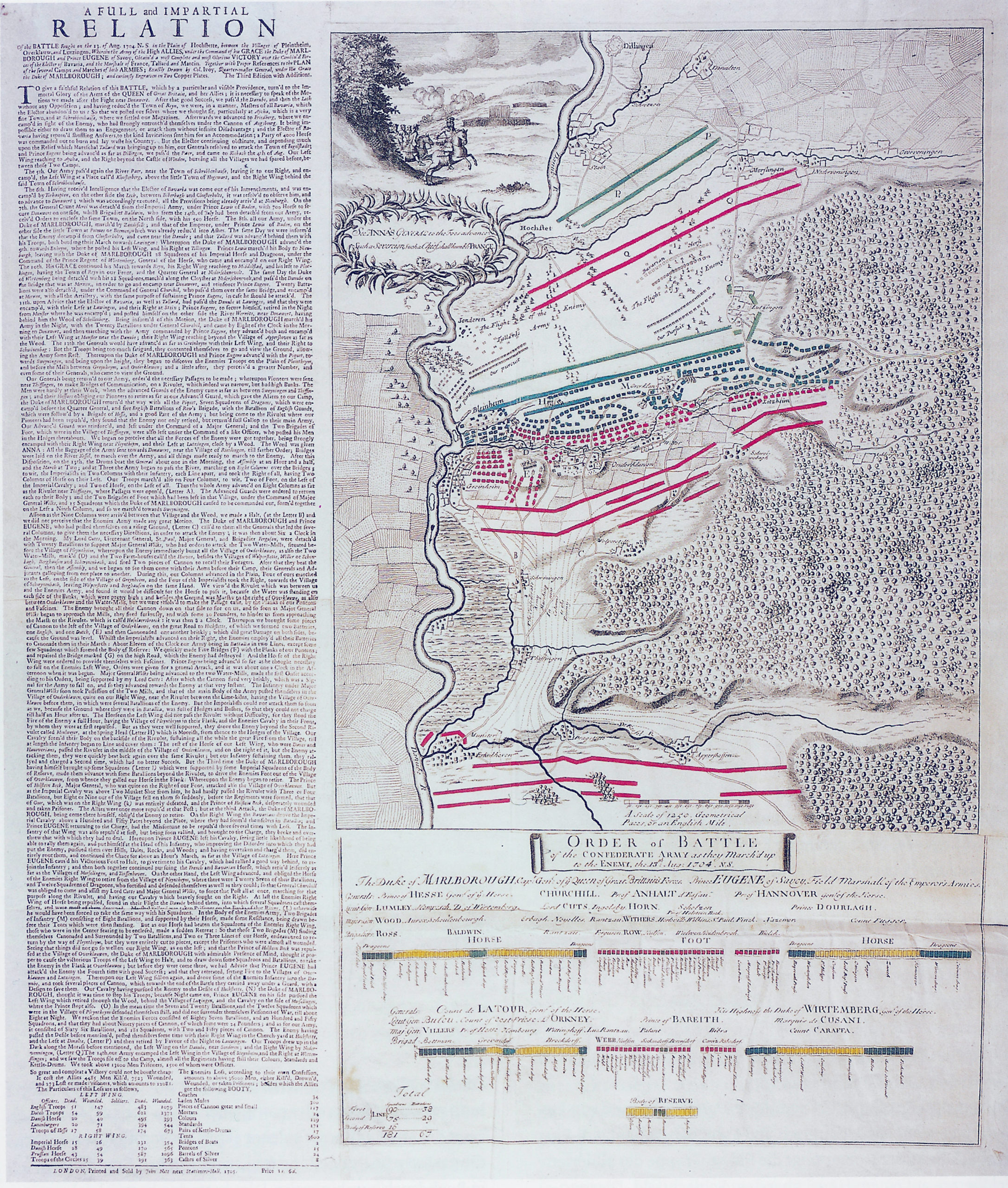
12.10 Professor Zenneti in his article in the 1908 issue of the Dillinger Historical Society’s year book titled ‘Bericht über die schlacht bei Höchstädt von einem Mitkampfer’ (pages 78-102), although mistaken in its origin, accidentally provides a well researched, critical appraisal of the flyer published in 1705 titled ‘A Full and Impartial Relation Of the battle fought on the 13th August 1704 (N.S.) in the plain of Hochstette, between the villages of Pleintheim, Overklau, and Lutzingen’, which was originally attributed to Colonel Ivoy, of the Quartermaster General’s staff.
References
- Ref 1:
- The flyer published 1705 and attributed to Colonel Ivoy, Quarter Master General under the Duke of Marlborough, (Map and account published in Brennpunkt Europas page 208 – 7.28 – Bayerische Schlösserverwaltung Zug. – Nr.932)
- Ref 2:
-
An interpretation of the content of Ref. 1 (enclosure 2)
- Ref 3:
-
A plan of the famous Victory at Blenheim (Public Record Office Ref. MR 483)
- Ref 4:
-
Topographische Karte 1:25000, published by Bayerisches Landesvermessungsamt München, Postfach 22 00 04 D- 80535 München, http://www.blva.bayern.de,
E-Mail: Poststelle@blva.bayern.de,
Numbers:-
7329 Höchstädt a.d Donau.
7229 Bissingen.
7330 Mertingen.
7230 Donauworth. - Ref 5:
-
Topographische Karte 1:50000,
Naturpark Augsburg-Westliche Wälder, published by Verein Naturpark Augsburg-Westliche Wälder e.V. Prinzregententplatz 4. 8900 Augsburg. - Ref 6:
-
Stadtplan Höchstädt a.d. Donau, flyer issued by the Gemeinde Höchstädt, showing the town layout in the early 19th century. Stadtgemeinde, Höchstädt a.d Donau. Rathaus, Bahnhofstrasse 10, 89420 Höchstädt.
- Ref 7:
-
Two eyewitness accounts of the battle of Blenheim published by ‘The Salacious Historian’s Lair, Military History 1660-1715, https://web.archive.org/web/20130109041224/http://www.kipar.org/military-history/kirkes_blenheim.html
Account of the Battle of Blenheim credited to the 1st Duke of Marlborough. Account of the Battle of Blenheim credited to Dr. Hare, Chaplain to the Duke of Marlborough. Ref. 7.1 and 7.2 are both contained in the Internet download of Ref. 7 - Ref 8:
-
Blenheim, Battle for Europe, Charles Spencer ISBN ß-297-94609-4 second impression published by Weidenfeld & Nicolson 2004.
- Ref 9:
-
Marlborough, his life and time. Sir Winston Churchill. Published Scribner New York.
- Ref 10:
-
Gais Hans, entries in the Matriculbuch for 1704, Schwennenbach.
- Ref 11:
-
Gais Hans, entries in Jahrbuch des Historischen Vereins Dillingen a.d. Donau, Herausgabe der Bezirk Schwaben, der Landkreis Dillingen.
- Ref 12:
-
Gais Hans, conversations with members of the communities of Oberglauheim and Schwennenbach.
- Ref 13:
-
Gais Hans, conversations with Dr. Georg Warishofer, Landkreis Dillingen Landratsamt, Grosse Allee 24, 89407 Dilliungen a.d. Donau.
- Ref 14:
-
Gais Hans, conversations with Frau Burgermeisterin H. Wanner, Rathaus Herzog-Philipp-Ludwig 10, 89420 Höchstadt.
- Ref 15:
-
Recovery of relics, conversations with Johann Mengele, owner of Mengele Bau & Putz GmbH, whose excavations of the bed of the Alt Donau recovered the majority of relics from the battle of Bindheim.
- Ref 16:
-
Size of the village of Blindheim in 1704, Burgermeister G. Gump, Gemeinde Blindheim Rathaus, Weiherbrunnen 9, 89434 Blindheim.
- Ref 17:
-
Size, shape and layout of Höchstädt’s defences in 1704, Dr. Georg Warishofer, Landkreis Dillingen Landratsamt, Grosse Allee 24, 89407 Dilliungen a.d. Donau.
- Ref 18:
-
Independent confirmation of UK source material, is not always provided by reference to the two Books by Professor Karl Staudinger, who was chief archivist of the Bavarian army at the time of the second centenary of the battle of Blindheim.
- Ref 19:
-
Professor Karl Staudinger’s books on the history of the Bavarian army, Das Königlich-Bayerische 2 Infanterieregiment ‘Kronprinz’, and the Bavarian army under the Elector, Max Emanuel 2nd . Vorgeschichte und Geschichte des Regiments unter Kurfürst Max Emanuel 1682 – 1726 auf heeresgeschichtlicher Grundlage.
- Ref 20:
-
Der blutige 13 August 1704, Dr Marcus Junkelmann, Jahrbuch des Historischen Vereins, Dillingen. 105 jahrgang 2004, Pages 73 to 200. Herausgabe der Bezirk Schwaben, der Landkreis Dillingen.
- Ref 21:
- Visitor’s guide to the exhibition Oudenaarde 1708. titled ‘A city, a King, a General’.
Note:-
- It is regretted that copyright prevents the copying of the various publications quoted as references, but copies of the original publications are available from the source addresses given. Confirmation of conversations can be obtained by contacting the addresses given.
- The scale given in the Ref.6 Flyer, ‘Stadtplan Höchtädt’ is incorrect. The scale bar shown is 75 metres , not 100 metres long. This means the subdivisions are each 25 metres. (Checked against Ref 4 No. 7329 Höchstädt a.d Donau)
Enclosures (For reference use only)
- Topographic map showing wood paths to the north of the Blenheim battlefield.
- 1705 Flyer. Titled A Full And Impartial Relation . . . .
- A modern interpretation of the account given in the flyer
- A copy of Professor Zenneti’s 1908 Dillinger Jahrbuch article titled Bericht über die schlacht bei Höchstädt von einem Mitkampfer (pages 78-102) (PDF)